
Taguig City – In a bid to help hasten rehabilitation of affected areas devastated by the eruption of Taal volcano, the University of the Philippines opens up its map data to the public for free.
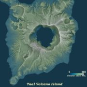
Through the UP Training Center for Applied Geodesy and Photogrammetry (UP TCAGP), the premiere state university is opening up to the public its map data of the Taal Volcano and its surrounding areas generated during the Disaster Risk and Exposure Assessment for Mitigation (DREAM) and the Philippine Light Detection and Ranging 1 (Phil-LIDAR 1) programs.
Using Light Detection and Ranging (LiDAR) technology, the group was able to generate maps with resolution of up to 1×1 meter which can be used for planning and reconstruction of areas damaged by the Taal volcano eruption.
UP TCAGP Assistant Professor Mark Edwin A. Tupas stressed the importance of using data in conducting planning and reconstruction activities in the areas affected by the Taal volcano eruption.
“With the Philippines being at constant risk from natural disasters, adequate data is needed for disaster risk reduction planning and operations, we are opening up our LiDAR map database to help in the rehabilitation of those affected by the Taal volcano eruption,” he said.
The DREAM and Phil-LiDAR 1 Programs are both projects funded by the Department of Science and Technology and monitored by the Philippine Council for Industry, Energy and Emerging Technology Research and Development (DOST-PCIEERD) which mapped riverbasins all over the country.
Tupassaid users of the map data would need to properly cite UP TCAGP and the PHIL-LIDAR Program as the source of the information.
“Please note that while stringent Quality Assurance/Control protocols were in place during the program operation, we cannot guarantee that the data is free of discrepancies, bugs or defects,” he said.
Tupassaid the datasets can be accessed through https://phillidar-dad.github.io/taal-open-lidar.html and can be opened using most modern geographic information system (GIS) software.
“From these high resolution information detailed 3D geovisualization, e.g. hillshade, can be created. The dataset can be also used for geomorphologic modelling of areas pre-disaster, data acquisition were between 2014 to 2017. Another sample use cases include the accurate determination of heights for building delineated from satellite imagery, given the Digital Elevation Modeling (DEM) of 20 cm vertical accuracy,” he said.
For further inquiries, you may contact the data archiving and distribution team of UP TCAGP at lipad@dream.upd.edu.ph.
—
Stay updated with news and information from the Department of Science and Technology by visiting their website at http://www.dost.gov.ph.